


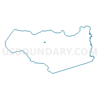
Voting District 43265, Contra Costa County, California
About
Outline

Summary
| Unique Area Identifier | 529826 |
| Name | Voting District 43265 |
| County | Contra Costa County |
| State | California |
| Area (square miles) | 0.18 |
| Land Area (square miles) | 0.18 |
| Water Area (square miles) | 0.00 |
| % of Land Area | 100.00 |
| % of Water Area | 0.00 |
| Latitude of the Internal Point | 37.97018790 |
| Longtitude of the Internal Point | -122.03899430 |
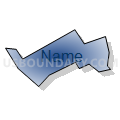
Maps


Graphs
Select a template below for downloading or customizing gragh for Voting District 43265, Contra Costa County, California


Neighbors
Neighoring Voting District (by Name) Neighboring Voting District on the Map
- Voting District 43225, Contra Costa County, CA
- Voting District 43410, Contra Costa County, CA
- Voting District 43445, Contra Costa County, CA
Top 10 Neighboring County Subdivision (by Population) Neighboring County Subdivision on the Map
Top 10 Neighboring Place (by Population) Neighboring Place on the Map
Top 10 Neighboring Unified School District (by Population) Neighboring Unified School District on the Map
Top 10 Neighboring State Legislative District Lower Chamber (by Population) Neighboring State Legislative District Lower Chamber on the Map
Top 10 Neighboring State Legislative District Upper Chamber (by Population) Neighboring State Legislative District Upper Chamber on the Map
Top 10 Neighboring 111th Congressional District (by Population) Neighboring 111th Congressional District on the Map
Top 10 Neighboring Census Tract (by Population) Neighboring Census Tract on the Map
- Census Tract 3361.02, Contra Costa County, CA (7,595)
- Census Tract 3270, Contra Costa County, CA (6,695)
- Census Tract 3361.01, Contra Costa County, CA (4,802)
- Census Tract 3362.01, Contra Costa County, CA (4,032)
- Census Tract 3350, Contra Costa County, CA (3,358)
- Census Tract 3280, Contra Costa County, CA (2,281)